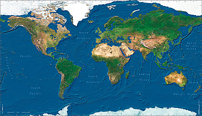
Pilots Atlas Satellite Wall Map

• Over 550 Airports shown by ICAO code
• High-resolution satellite image in photo quality
• laminated print, 88 x 150 cm (35 x 89 inch)
• High-resolution satellite image in photo quality
• laminated print, 88 x 150 cm (35 x 89 inch)
Sales price 19,95 €
Sales price without tax 18,64 €
Discount
Tax amount 1,31 €
Price / kg:
Description
The fascinating view of our Earth from the Astronaut's eye. The Pilots World Satellite Wall Map. High-resolution satellite imagery in a photo quality, laminated print, 88cm x 150cm. The specialty for Pilots lies in the exact placement of over 550 airports and their ICAO codes.